I’m loving that I have coworkers that enjoy adventures as much as I do! Since the snow hasn’t hit yet, a lot of Yosemite is still pretty hike-able and we took to the trails a few weekends ago to hit Chilnualna Falls, a hike right in Wawona just past the lodge. We got to the trailhead pretty early and there was only one other group of people there.
The hike started out pretty uphill but we got a peak of some falls almost right away!
It was pretty chilly to start the hike so we were bundled, but within a short distance we were all de-layering ourselves. After these falls, we started on some switchbacks with a steady climb; for that I was thankful for, after it only being a short while since my climb up to Yosemite Point.
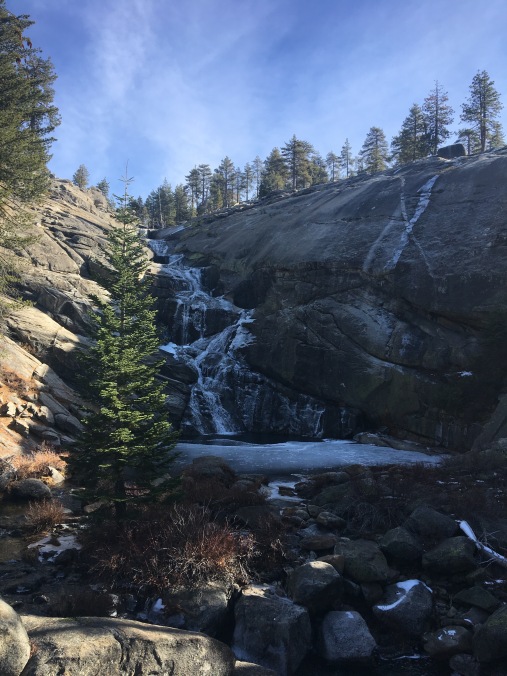
Before long we made it up to the top of the falls! It was pretty icy up there.
Some of the crew:
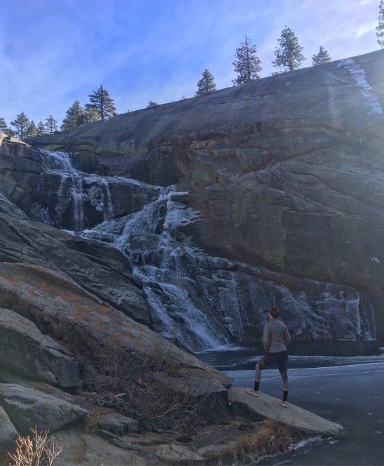
A little more up and we came to a crossroads and weren’t quite sure where to go… but we knew we wanted a closer peak at the falls so we crossed a little stream and got some pretty epic views…
It was frozen and beautiful!
We took a bunch of pictures, ate some snacks and relaxed in the sun before making our way back down. A friend dared me to go climb on some rocks way out over the view when we were headed back, so naturally I had to do it…
See me on the right? Hey!
We eventually made our way back down and headed back to town – the perfect day hike in Yosemite!
Being away from family is hard around the holidays, but there are ways to enjoy the day even when thousands of miles from your closest loved ones. Hiking, is the activity that I chose to take up my Thanksgiving this year – who would’ve thought?! 😉
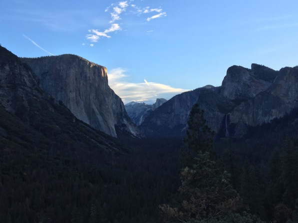
Tunnel view at dawn
Since I am going back east for Christmas, it wasn’t feasible for me to get home for Thanksgiving too, so I hung around here and planned out a big hike: Yosemite Point via the Upper Yosemite Falls trail. This trail is about 4.2 miles up (and I mean up) with an overall gain of over 4,000 feet. It did not disappoint and to date, is one of the toughest but most rewarding hikes I’ve done.
I can’t stress this tip enough: start early. The climb is no joke, there are endless rocky switchbacks that are super steep. I got to the trailhead around 7:45am and started my trek.
Immediately, the uphill climb started. Before long you reach Columbia Rock (about a mile in) and are rewarded with some views of the valley.
The early morning was casting some weird shadows over the valley but it was still beautiful. I didn’t stop long, as I knew I had a long uphill climb ahead of me and I only know one speed when hiking! I kept climbing upwards and eventually was treated with a short downhill portion. It was a pleasant treat but I knew the worst was yet to come. Soon I rounded a corner and was treated to a view of the falls!
The views were already unbeatable and I couldn’t wait to get up to the top! This is where the rocky, exposed switchbacks started and they were tough. It was only in the 9:00 hour and it was already hot! I stopped for a brief period a few times but continued trekking up.
I got excited when I started to see more greenery, because I knew I was almost there! Next thing I knew everything was leveling out and the path was leading me to the edge.
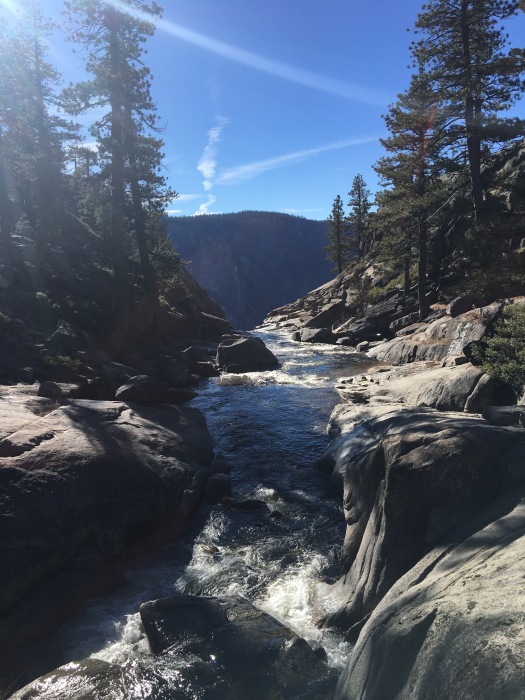
Made it! It was a loooong way down. I went down to the waterfall’s edge where you follow some steep steps with handrails before turning back and jumping back on the trail up towards Yosemite Point. I was treated to this view of the water leading down in to the falls which was beautiful.
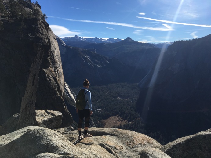
It’s about .8 of a mile to get up to Yosemite Point, but if you have the energy/time/daylight to do it, it’s a must. My legs were shaking by the time I got up there but you guys…
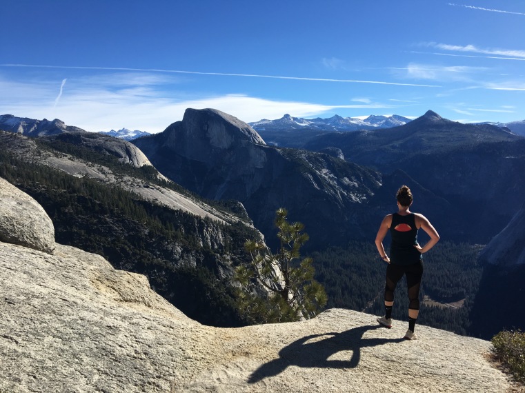
You’re rewarded with the most incredible view of the park and of Half Dome with the Sierras all across the skyline. It was unreal. I stayed up there for a snack and to take lots of pictures and then turned around and returned the way that I came. Those switchbacks were plain hard going up, but coming back down was scary! It’s two days later right now and my muscles are SO sore, but it was worth it.
With the sun up a little higher in the sky on the way down, it was hot! I couldn’t believe how many people were on their way up at the 11 o’clock hour. Do yourself a favor and don’t put yourself through that, start early! I had 3L of water with me and went through 2L easy, and cracked open my 1L bottle on my way down.
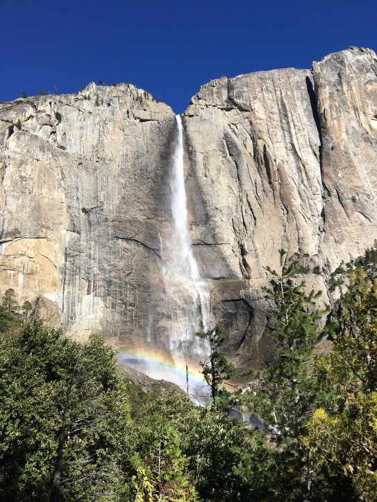
On the way down, you’re treated with even better views of the falls at this time because of where the sun was hitting them…
Beautiful!
I went quick on the way back down, to the dismay of my knees and quads, but I really only know one speed and I get anxious to finish the hike on the way back down, haha! Once I hit Columbia Rock, the crowds started up and I had to pass a lot of people. Luckily most were kind and would hear me coming and pull off to the side – trail courtesy at its finest. I was surprised to see how crowded it was, given that it was Thanksgiving Day, but it also made me happy to see so many people enjoying the beautiful park together on a day that’s all about being thankful.
Overall, it was one of the best hikes I’ve ever done. From my car back to my car I covered 9.38 miles in a little over 4 hours with a 4,000+ foot climb.
This weekend I ventured out to my 13th National Park: Pinnacles!
This is one of the newest National Parks in the country: it was only named a National Park about 5 years ago, formerly a National Monument. It’s on the smaller side with only about 30 miles of trails to explore, but none the less, still beautiful! I headed to the East entrance and made my way to the Bear Gulch Day Area to begin my hike on the High Peaks Trail.
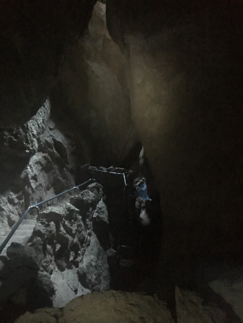
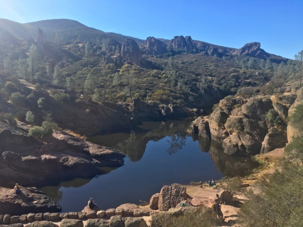
I opted to take the detour to add in the Bear Gulch Caves and Reservoir. The caves were a cool addition to this hike since most of my hiking has been high up in mountains – you do need a flashlight if you go in to the caves, so I made sure to grab one at the visitor center before heading out to the trail.
There were a lot of steps and a lot of narrow spaces – I had to squat down and crab walk a few times to get through some of the spaces!
Obviously it’s hard to see cause it was dark, but you can see the stairs on the left side that I climbed up.
Before long I continued up and made it to the reservoir.
I didn’t linger too long because I knew I had a lot more to see. I followed the Rim Trail from the reservoir upwards until it linked up with the High Peaks trail. Before long I was getting epic views of the rotund shaped mountains that give the Pinnacles their namesake.
I continued to climb up and eventually hit some sandy switchbacks which was brutal and exposed. It was hot! The temperature was only around in the mid-60s I believe but the sun was strong and high.
I saw this cool rock tunnel, and failed at a selfie-timer attempt before other hikers came up behind me…
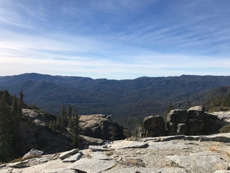
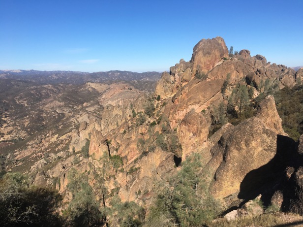
Before long I made it to (what I thought was) the top. There were awesome views of the surrounding mountains and you can even see the San Andreas fault from some of the view points!
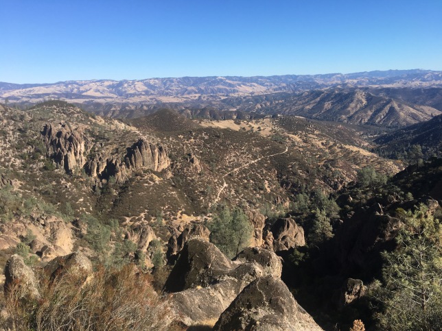
I continued on along the High Peaks trail where I saw a “warning” sign of steep and narrow trails ahead – oof, I thought I had finished with the climbing. There was a good portion of the next part of the trail that had railings to allow you stability while climbing large steps…
And some railings that were just providing you safety from dropping hundreds of feet down. The views didn’t stop along the way…
Eventually I made my way back around to some intersections where I followed signs to return to the Bear Gulch Day area. By the time I made it back to the car, I had gone about 6 miles and climbed about 1,300 feet in elevation – not a bad day at the park!
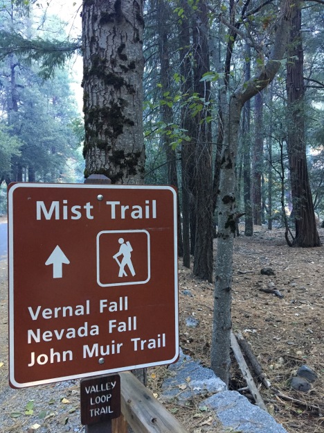
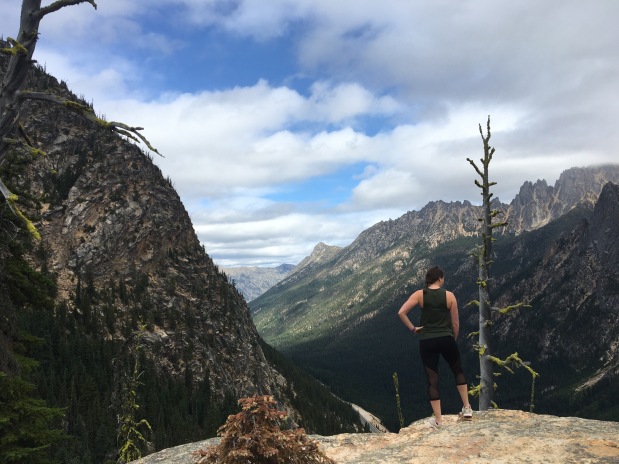
Two weeks ago, I ventured back out to Yosemite to tackle the Mist Trail to the top of Nevada Falls! I really have been trying to get out to Yosemite before the snow hits and the roads and trails start closing. This one did not disappoint and was a great climb.
The trail was pretty easy to find and we got there early which was a great decision – it was pretty crowded when we were coming back down. We were anticipating a steady climb and right from the get go, we were climbing! We went up through some beautiful canyons up a steady hill until it leveled off a bit where there were restrooms and a water station. Then after a short walk we hit the stairs that led us to Vernal Falls!
Those stairs were no joke…
But soon enough we made it to the look out for Vernal Falls…
Being late October, the falls were very low, but still beautiful! This trail is called the Mist Trail because when the falls are at their peak, the stairs and trail get soaked with the mist from the falls, I could only imagine how treacherous those stairs would be while wet… they were hard enough bone dry.
Before long we were at the top of Vernal Falls…
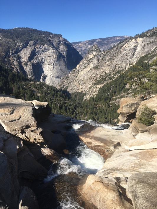
We enjoyed the views of where we just came from (see that trail to the left, that’s the route we took up!), and eventually continued on towards Nevada Falls.
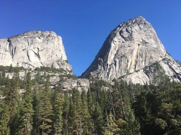
We had some great views of surrounding rock formations as we made the steady climb up and we eventually saw Nevada Falls ahead. We pulled off the trail to get a good view of the falls straight on…
Then we made it back to the trail to climb, climb, climb up the last steep portion of rocky steps…
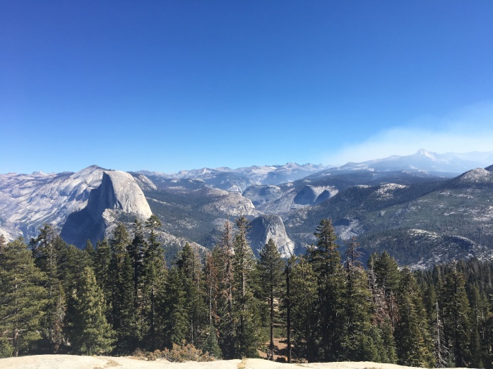
Until finally we made it the top!
We hung out, ate some lunch and snapped pictures at the top, taking it all in after the 1,200 foot climb.
We had hopes of heading back down following the Jon Muir trail so we could get some different views of the canyon and valley, but a portion of the trail was closed due to damage. That meant we unfortunately had to head back down the steep steps which my knees were not happy with, but going down was a lot quicker than coming up.
Overall it was a beautiful day for hiking this trail! I’m looking forward to getting to see more of Yosemite before the winter strikes, and hopefully I can find a way to get up there to explore when the snow hits.
You didn’t think I could actually move within 45 minutes of the gates to Yosemite and wait more than 24 hours to check it out, did you? Because I couldn’t.
I flew back in to Portland Wednesday night, got a few hours of sleep and headed south! I got to Fresno after a little trek down the Oregon coast…
Until I eventually hit California and Redwood National Park! I didn’t get a chance to do a ton of exploring, but it was still cool to drive through the scenic highways surrounded by the giant trees!
I got to my “home” for the next three months on Friday, and Saturday morning I was up and driving up 41 in to Yosemite! I did a little research on some shorter hikes with killer views, since I was pretty out of hiking-shape and didn’t want to commit to a long day. I ended up driving to Tunnel View – not realizing that I passed the hikes I planned on going to, on my way there. Regardless, it was a cool view, albeit, WAY overcrowded.
I retraced my way in to the park and headed back towards the road to Glacier Point. I realized later in the day that it was a “holiday” weekend (Columbus Day), so now I see why it was so insanely crowded. I hate crowds. Especially when I just want to hike and embrace nature and you’re stuck behind a family of 6 with small children screaming.. *eye roll*.
I did the Sentinel Dome hike, which was short but worth it! Great views of El Capitan…
And Half Dome…
Once that was finished, I kept going down the road and reached the parking lot for Glacier Point. If you’re planning on going here, I highly recommend going EARLY. I waited 30 minutes just to get in to the parking lot and got so annoyed that I just ended up driving around everyone. I ended up finding a spot on the side of the road on my way out, which was lucky but I snagged it. I made my way over to Glacier Point…
It was a solid introductory day to Yosemite!
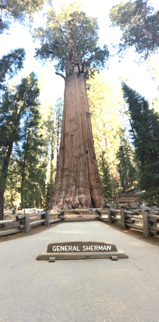
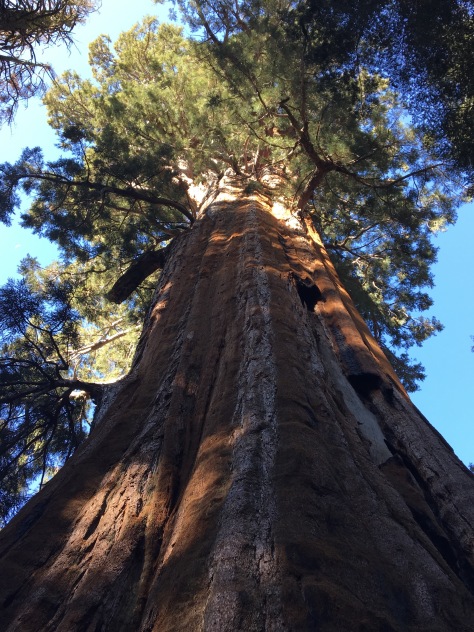
This past weekend I got to go check out Sequoia! I stopped at General Sherman… The largest known tree, by volume, in the world.
I ventured around the Congress Trail where I saw the President…
& the Senate…
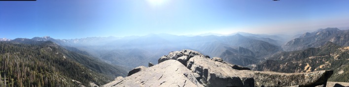
After about three miles I made it back to my car. My next stop… Moro Rock!
This was a short, super steep hike, up a bunch of stairs…
That led to a panoramic view of the High Sierras and the valley!
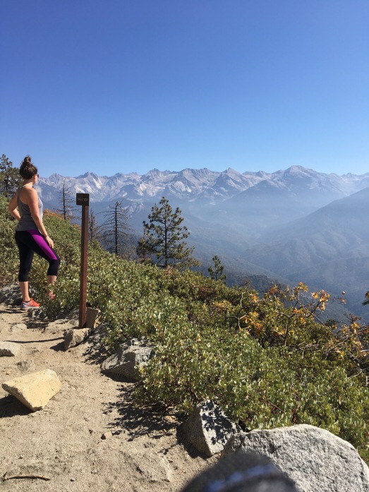
My last stop for the day was around the corner at Crescent Meadow! I ended up reading my directions wrong and walked about 2 miles more than I was supposed to, but it was all beautiful so no complaints! Eagle View, a section of the High Sierra trail, was my plan…
So in my first week at my new assignment, I’ve successfully checked 3 National Parks off the list!
A few weekends before my contract was up, a few of my fellow travel friends and I hit the road headed way north to escape the horrible valley smoke we were all inhaling for a week. The wild fires have been so horrible this year in Oregon – worse than other years, I’m told – and it’s literally been like you’re walking around inside of a campfire whenever you’re outside. We were happy to get away a bit, even though it meant a good bit of driving.
Devon picked me up on her way North from Roseburg, then we hit Albany and joined up with Kristen – then we were off to Everett, Washington! Devon has some travel friends living there and they gratefully offered up their couch/floor space to us so that we could go explore North Cascades National Park!
The night started out smoothly… Until Kristen’s car decided to pop a tire, on I-5, in the middle of Washington, still 100+ miles from Everett. Ugh. We called AAA, they said it would take them over an hour, we said okay… We hung up then said, let’s just change it ourselves! We “phoned-a-friend” and he walked us through it and within 20 mins, we had a new tire on there! Now I can say I know how to change a flat tire, life lessons. We hit the road and finally got up to Everett a little after midnight – we immediately went to sleep. Upon waking up, we first had to get Kristen a new tire. We stopped at a diner while she sorted that out then joined us while we waited for the car. Eventually we were on our way to North Cascades!
Our original plan was for a pretty intense (what we thought was 8 miles but found out at the visitors center, it was not) 10 mile hike with a 5000′ gain. But with the late start – we didn’t get in to the park until noon – the weather, it was raining and super windy, and recommendations from the rangers at the visitors center, we opted to skip that hike and think about doing a shorter one.
Our first stop though: Diablo Lake!
The hike we were planning on would have taken us to one of the peaks above Diablo, giving you an incredible view of the surrounding mountains and of course, the stunning blue of Diablo Lake. The lookout was just as stunning, rain and wind and all.
As we drove through the park, we passed trailheads and read up on them as we passed them, initially planning on going for a 7 miler. We ended up stopping at Washington Pass Lookout and, you guys…
Unreal.
Epic views.
We ended up scratching the 7 miler at this point and ended up going for the 4 mile hike to Blue Lake. I like that our day went from YEAH 8 mile hike! to NO 10 mile hike. to 7 mile hike! to Yeah lets just do 4. It was the perfect day though just exploring. That’s the thing about national parks – you really can just drive through them and experience so much.
Blue Lake trail was easy to moderate – there were some up and downs but it levels off around the middle in a meadow.
And before you know it you’re there!
I went around and explored different view points while my friends went the other way, my direction was a dead end with less views so I went to meet up with them on the other side. We found the perfect spot to relax and drink a beer.
It started to rain a bit harder so we packed up our stuff and hit the road back to Everett. Our night consisted of drinking beers, ordering in Chinese food and playing card games – basically laughing and just enjoying each others company. It was a great weekend away!
I feel like throughout life people make bucket lists for various reasons. Regardless of the reason, there’s something so stimulating and empowering about making a list, and proceeding to cross things off of it.
That being said – I think it’s time to talk about my latest Bucket List Challenge that I’ve set forth for myself…
30 NATIONAL PARKS BEFORE 30
Crazy? Maybe. Do-able? Definitely. Expensive? Probably. Experience of a lifetime? Yes.
As of right now, I have been to seven. With 4 of those being in the last 3 months, two when I was younger, and one in PT school. That leaves me under a year and a half to hit 23 more National Parks. So far I have been to…
Acadia National Park in Bar Harbor, Maine.
(My grandfather lives across the street from the entrance to the park, I’m sure I have tons of pictures at home, but none digital)
Grand Canyon NP in Arizona.
(Again, no digital pictures, but I visited when visiting my sister in Arizona one year… I plan on going back to check out some other spots and do hiking)
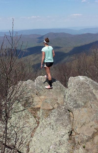
Shenandoah NP in Virginia.
Badlands NP in South Dakota.
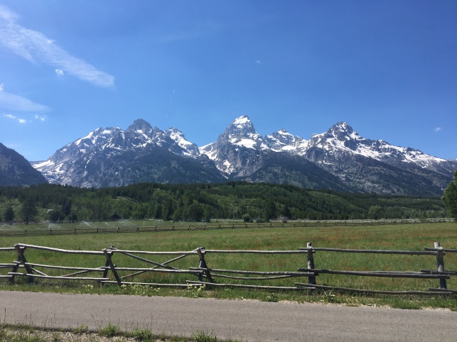
Grand Tetons NP in Wyoming.
Crater Lake NP in Oregon.
Mount Rainier NP in Washington.
Fortunately, there are a ton in the west that can be knocked off a few at a time with a solid road trip plan. I’m planning on checking a bunch off the list during my next contract in California – obviously with Yosemite way high up on that bucket list. And I plan on making a trip to Utah and hitting Zion, Canyonlands, Arches, Bryce Canyon and Capitol Reef in one epic road trip.
Now it’s on paper (digital paper), and now you all can hold me accountable. It’s going to be an adventure, but what’s life without epic adventures?!
I love the mountains. The mountain air. The snow caps. The sky line views. The overwhelming power that these massive structures hold. The way that they can make you, and all of the world’s problems, feel so small. Mountains may be one of my favorite things that Mother Nature has blessed us with.
With only a few weekends left in Oregon, I knew I needed to get up to Washington at some point and last weekend was it. The mountains were calling to me, so up to Mount Rainier I went!
I left after work on Saturday and drove the 4+ hours up to Tacoma where I booked a hotel for the night. It was less than stellar and I got a horrible nights sleep, but I woke up at 6am ready to tackle some mountains!
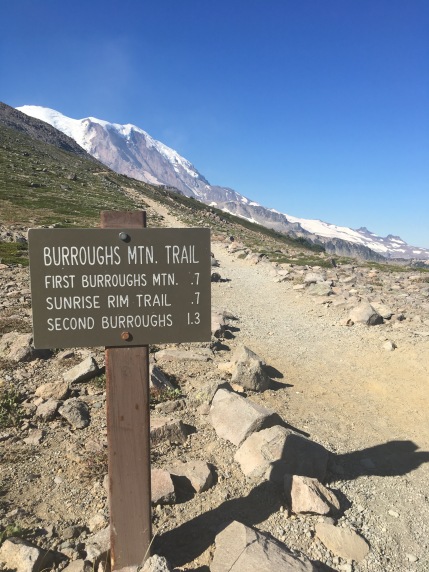
This trail started at the Sunrise parking lot area. I got there around 9am and was ready to roll – I wanted to get there earlier but even in Tacoma I was still about 2 hours from the trailhead. The parking lot wasn’t too full yet and I got a great spot. Off I went!
This trail was great, albeit, tough. The link above will take you to the AllTrails description of this hike. There are 3 Burroughs, the First, Second, and Third. Most people hike to the 2nd Burroughs and turn back, making it about a 6 mile hike. I opted to push on further and continued to the 3rd Burroughs which made is 8.8 miles round trip – according to my Garmin.
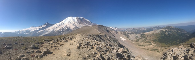
It was very exposed with zero covering which made for a very hot trail, even with getting there so early. The end views were SO worth it though. From the top of the third Burroughs, you’re pretty much staring Mt. Rainier in the face, and are able to check out the beautiful glaciers all along the Northeast side of the mountain.
Absolutely stunning.
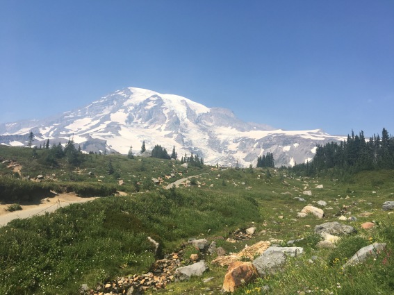
After the trek back – I ended up jogging any of the straight aways and I made it back in under 3 hours – I was ready for a cold drink and some AC. I stopped in the gift shop for a Gatorade and a sticker, then hopped in my car and made my way around the park to the Paradise Inn for one of the more popular trails – Skyline.
When I say this is more popular, I mean, oh my goodness-people-get-out-of-my-way popular. It was pretty annoying, there were a ton of people in the beginning with lots of kids and it was a STEEP climb from the get go. So definitely go early to avoid crowds – I didn’t get there until about 1 or 2 I think. So not only was it scorching hot at this point (with again, no cover), but the crowds of people were frustrating.
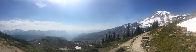
But, I didn’t let the people take away from the amazing views of the South side of the mountain…
You got pretty close to the mountain and the glaciers, but not as intensely as with the Burroughs. One amazing thing was that I could hear the cracking of the glaciers. I didn’t notice it at first, then when I realized what it was, I just stared at the mountain in awe. Ugh, Mother Nature just gets me.
This hike was a pretty steady climb in the beginning, leveled out a bit, then another steep climb on some rocky ground, before eventually descending down rocks. I think I shortened this one a bit and didn’t do the whole 5.5 miles – it was hot, I was tired, my legs are hurting, and I had a 4.5 hour drive ahead of me.
It was such an epic day though. Just what the doctor ordered – 14.5 miles, over 3,000 feet gain for the day (maybe even 4,000+), just me, my thoughts and the mountains.
And just like that, it’s been over a month since I last posted. Looks like we have a lot of catching up to do…
I’m now more than halfway finished with my contract. Whoa. Time has certainly flown by and it’s making me anxious and excited for where I’m heading next. I don’t know where I’ll be, but I know it’ll be an awesome adventure. So what have I been up since we last chatted? Hiking, duh. And working. And meeting friends. And falling deeper in love with the PNW.
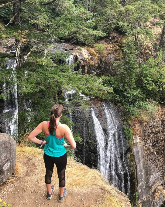
I’ve seen a lot of waterfalls… like, a lot.
I ran the Trail of Ten Falls in Silver Falls State Park, which featured, obviously, ten waterfalls.
South Falls – I started here at the South parking lotNorth Falls – One of my favorites of the 10!Upper North Falls – photo cred to the couple I kept creeping up behind
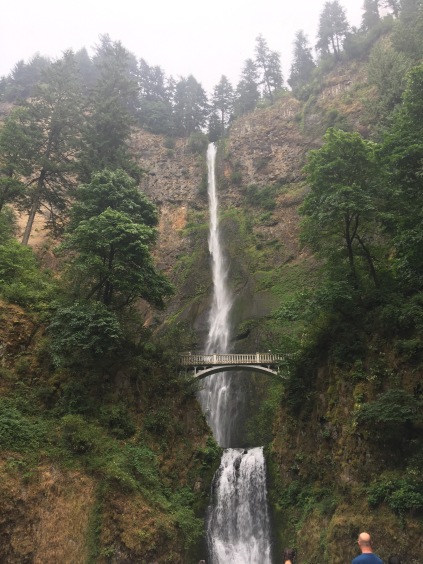
I went up to the Columbia River Gorge area and saw Multnomah Falls, the tallest in Oregon.
And checked out Horsetail Falls…
And even hiked through waist deep water to get to Oneonta Falls! (Disclaimer: the hike to get to Oneonta was pretty epic, through a canyon and along (in) the creek – BUT, it was so, freaking, crowded. Like, families bringing small children and dogs over these huge log-jams which meant more waiting time for others (I went around the line and climbed up a different way). It definitely took away from the experience a bit)
While in the Gorge, we checked out Punchbowl Falls as well…
More recently I checked out Silver and Golden Falls, outside of Coos Bay…
Silver FallsGolden Falls
And last weekend, I went and explored Salt Creek Falls, extending my hike to see Diamond Creek Falls!
Who knew Oregon had so many dang waterfalls?! 238, to be exact… I just Googled it.
I got to experience Crater Lake National Park in all of it’s incredible, epic beauty.
A butterfly actually landed on my finger…Mount Scott
And my personal favorite picture, unedited…
I went to a Portland Timbers game! And they won!
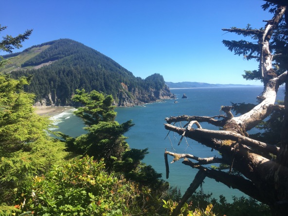
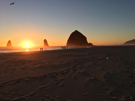
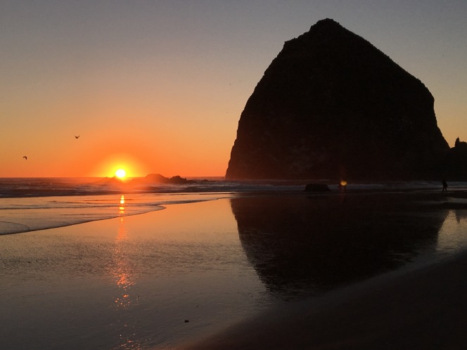
I went to the coast and hiked, then watched the sunset at Cannon Beach…
Hug PointCape Lookout – it was like a rainforest, and there was no look out due to fog 😦Cape Falcon
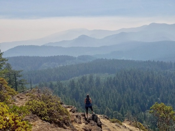
And I climbed a little mountain…
Those layers though…
I only have FOUR weekends left in Oregon, unless I decide to extend my contract, which I would only do if I can’t find anything that I want. But that just means I have to make the most of these next four weekends!
Unfortunately, the forest fires have been pretty bad out here and are ruining a lot of my plans – including a 12-mile summit hike we were planning on doing in 3 weeks… which as of right now, the trail is closed due to fires. Ugh. But we have a plan B, which is to head up to Mount Rainier, so either way it will be a great weekend!
I’ll try to be better about posting – at least once a week so I can really tell y’all about my weekends, rather than just photo dumping things on ya!
This past weekend I got the chance to explore see some waterfalls and some mountains – the perfect weekend if you ask me!
Sunday
Sunday morning started bright and early as I made my way to Albany to meet up with Kristen. From her house, we grabbed her co-worker and then made our way to Mount Hood National Park where we planned to attack the Tom, Dick and Harry Trail by Mirror Lake!
The parking lot was full by the time we got there a little after 9am, so we had to park about a mile up the road before walking to the trail head. Get there early on the weekends to avoid this, but it wasn’t terrible and there was a path to follow along the road.
After about a mile of a lot of dirt switchbacks, we reached Mirror Lake! Our goal was to get to the top of Tom, Dick and Harry Mountain, so we didn’t stay too long at the lake and opted to do the loop on the way back. Up, up, up we went until…
Breathtaking.
Snow caps of Mt. St Helens, Mt Ranier and Mt Adams
The trail was easy to navigate since it’s pretty heavily traveled. The last bit to get to the summit was a lot of rocks, but nothing too strenuous. The views were all 100% worth it. We hung out at the time for awhile and all agreed that we could have stayed there forever. But eventually we started to make our way back down.
We went around Mirror Lake the opposite way to see the classic Mirror Lake view with Mt. Hood in the background.
Then we made our way back to the car for a total of 7.2 miles (per my GPS watch). After the hike we headed up to the Timberline Lodge which sits right on Mt. Hood and has ski lifts to take skiiers/snowboarders up towards the top. There were actually people skiing – in July! The lodge was really cool to walk through and check out, so I would definitely recommend a pit stop there if you’re in the area. We ended our day with some lunch at Mt. Hood Brewing Company, then made the trek home!
Monday
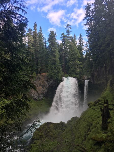
I stayed a bit more local and explored the Willamette National Forest area – Shahalie Falls, Koosah Falls, and the Blue Pool were on my list to see!
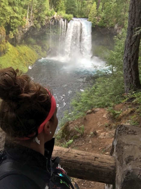
First up: Shahalie Falls!
The trailhead to the Waterfall Trail actually starts at Sahalie Falls. I got there around 8:45 and there were only 1-2 other cars in the lot.
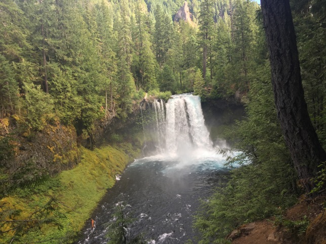
After stopping to check out Sahalie Falls at the trailhead, I started down the path to Koosah Falls. It was down stream, so downhill and flat which made it perfect to get a little jog in. I ended up speed walking/jogging until I hit Koosah, stopping every now and then to look at my surroundings.
I kept going down to the Carmen Reservoir and debating continuing on to the Blue Pool which I knew was 3 miles down, but I didn’t have service and didn’t have a map.. So I decided to go back up to the car. Once I ran back, I realized that because I didn’t have service, I couldn’t look up how to drive to the Blue Pool either…
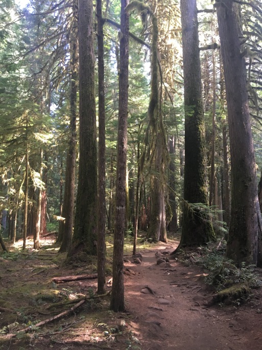
Then I remembered that I took a screenshot of the directions the night before when I was researching – WIN! I never would have found it otherwise; there were zero signs leading me to the trailhead, but once I found it I knew I had arrived by the line of cars along the side. To get there, you want to turn at to the Trailbridge Campground sign, take a right once you go over the bridge, continue up the gravel road about a third of a mile and you will see the trail sign on the left.
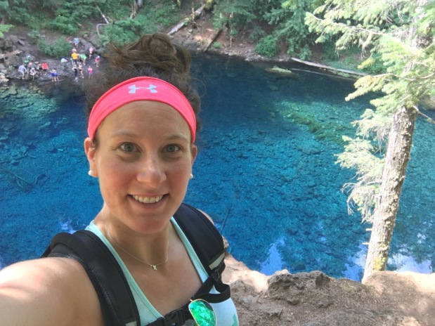
According to my watch, it took me about 2 miles to get to the pool. The trail is pretty rocky in some parts but follows the river and is fairly flat overall considering some of the other trails I’ve been doing. But before I knew it, I was there…
There is zero filter on this. Zero. The water is THAT blue. It was incredible.
I didn’t make the trip down to the water, but watched a lot of others climb down. One crazy lady even jumped in – I’ve heard the water temps aren’t higher than 40 degrees, no thank you. I could have sat there and stared at the water forever, it was just unreal.
I met a very nice older couple who actually are originally from PA, right outside of Maryland! It’s such a small world and is so fun to meet all of these people. We chatted for a few minutes and they offered to snap some pictures for me, which I was thankful for because my selfie game is only so strong…
After saying bye to my new friends, I hit the trail and headed back to the car. It was about 4 miles total once I got back to my car.
And that wrapped up another solid weekend exploring the PNW. It’s getting harder and harder to justify going back east…